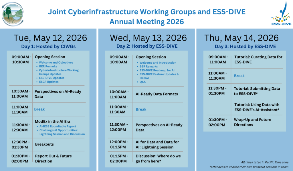
ESS-DIVE

Deep Insight for Earth Science Data

CONTACT
  • DATA
    • SEARCH DATA
    • SUBMIT DATA
    • ACCESS DATA PORTALS
    • DATA PRESERVATION
    • TERMS OF USE
  • ABOUT
    • WHAT WE DO
    • OUR TEAM
    • OUR COMMUNITY
    • OUR COMMUNITY PROJECTS
    • OPPORTUNITIES
  • GET STARTED
    • GUIDE TO USING ESS-DIVE
    • DATA SUBMISSION GUIDELINES
    • PROPOSAL GUIDELINES
    • DATA REPORTING FORMATS
    • DATA USE AND CITATION
    • FAQs
  • LEARN MORE
    • NEWSROOM
    • WEBINAR LIBRARY
    • TRAINING EVENTS
    • TRAINING VIDEOS
    • PUBLICATIONS
    • ACRONYMS/GLOSSARY

February Webinar on ESS-DIVE and Urban Integrated Field Laboratories Data

February 1, 2023 by Dylan O'Ryan

February Community Webinar

Monday, February 27 | 10:00-11:00 PT / 13:00-14:00 ET

View Webinar Recording / Link to Webinar Slides

ESS-DIVE is excited to welcome Urban Integrated Field Laboratory (Urban IFL) projects to the community. We invite all who are part of an Urban IFL project and the broader ESS community to an introductory webinar about the ESS-DIVE data repository for Earth and environmental system science data, and associated resources for project data management. We will also have a discussion on data management needs for Urban IFL projects.  

We will cover the following topics:

  • Overview of ESS-DIVE and our data;
  • ESS-DIVE project data management features; 
  • Resources to organize and curate high-quality datasets; and
  • Discussion on Urban IFL data management needs.

Please encourage anyone from your project who may be interested to attend. 

The webinar will be presented by Joan Damerow and Emily Robles.

Joan Damerow, Community Engagement Lead Scientist

Joan is an environmental scientist with a diverse background in geoscience sampling, freshwater ecology, and biodiversity informatics. She runs engagement activities for ESS-DIVE, including ESS-DIVE webinars, our community data workshop, and is active in relevant conferences and data working groups (e.g. ESIP, RDA, AGU). Joan is interested in interdisciplinary data management and tracking, and works with our community of data contributors to identify, develop, and implement practical data standards in ESS-DIVE that support FAIR principles.

Emily Robles, Data Management Research Associate

Emily is a research associate and a member of ESS-DIVE’s Community Engagement team. Her work with ESS-DIVE focuses on utilizing community research and feedback to implement a comprehensive data package review workflow for data publication. She has experience with data package organization and quality management as a member of the NGEE Tropics data team and received her BS in Environmental Science from the University of California, Berkeley.

Filed Under: Homepage Features, news

January Webinar on ESS-DIVE’s Reporting Format for UAS Data and Metadata

December 22, 2022 by Dylan O'Ryan

January Community Webinar

Monday, January 30 | 10:00-11:00 PT / 13:00-14:00 ET

View Webinar Video / Link to Webinar Slides

Are you interested in publishing or using data from small Unoccupied Aerials Systems (UAS)? With rapid development of platform and sensor technologies, the use of UASs, also known as UAVs or drones, in Earth sciences is becoming increasingly common. This webinar will review the new UAS data and metadata reporting format that is in development, and provide you an opportunity to give feedback.

We will cover the following topics:

  • Benefits of using reporting formats,
  • Types of data that this format will cover and associated challenges,
  • Metadata variables to describe flight details and equipment, 
  • Categorizing data by processing level, and
  • Discussion and feedback. 

You can review the draft UAS data and metadata reporting format before the webinar, although this is not required to attend.  This webinar will be presented by Kim Ely and Shawn Serbin from Brookhaven National Laboratory (BNL).

Please encourage anyone from your project who may be interested to attend.

Filed Under: Homepage Features, news

ESS-DIVE at AGU 2022

December 2, 2022 by Dylan O'Ryan

The ESS-DIVE Team is looking forward to participating in the 2022 AGU Fall Meeting. Below are several abstracts that we will be presenting at the meeting!

BASIN-3D: Data Synthesis Software for Earth Science Researchers (H12P-0874)

Presenter: Danielle Christianson
Presentation Type: Poster
Session Date and Time: Monday, 12 December 2022; 9:00 AM – 12:30 PM CST / 7:00 AM – 10:30 AM PST
Session Number and Title: H12P: Hydroinformatics and Data Science: Pathways to Support Reproducible Watershed Modeling II Poster
Session URL: https://agu.confex.com/agu/fm22/webprogrampreliminary/Paper1153073.html

Abstract

Danielle S Christianson, Valerie C Hendrix, Catherine Wong, Charuleka Varadharajan, and Deb Agarwal, Lawrence Berkeley National Laboratory, Berkeley, CA, United States

Integration of diverse data required for earth science research remains a time-consuming task. While approaches such as data warehousing and federation (brokering) have reduced effort, the difficult work of harmonizing formats, units, and semantics remains for the individual researcher. Often the resulting one-off data synthesis products become outdated as data change. In addition, the researcher does not have flexibility to tailor synthesis to specific data needed.

In this presentation, we describe BASIN-3D (Broker for Assimilation, Synthesis and Integration of eNvironmental Diverse, Distributed Datasets), a tool we developed to address this gap. BASIN-3D synthesizes diverse data from a variety of remote and/or local data sources in real-time without the need for additional storage. The software can be deployed as a python package in python-based applications like Jupyter notebooks or as a web service application. Data sources can be configured using a plugin approach that maps their data model and vocabularies to BASIN-3D’s. These mappings enable BASIN-3D to handle translation of query parameters and results into a standardized data model. BASIN-3D then outputs the synthesized results in common data formats (e.g., hdf5, Pandas dataframe, json) specified by the researcher.

We describe the unique features of BASIN-3D using two prototype U.S. Department of Energy use cases. The first is a python-based application that combines USGS National Water Information Systems NWIS and DayMet time series data to support study of disturbances on river water quality with ML techniques. The second is a Django web-based application that integrates time series data from NWIS and project-based databases for access via an online data portal. Finally, we discuss future work and ongoing challenges such as optimization for large data volumes, adding new data sources, and tradeoffs between generalization and customizability.


Community-developed (meta)data reporting formats to enable data reuse in environmental repositories (IN41A-06)

Presenter: Charuleka Varadharajan
Presentation Type: Online Poster Discussion
Session Date and Time: Thursday, 15 December 2022; 8:40 AM – 8:48 AM CST / 6:40 AM – 6:48 AM PST
Session Number and Title: IN41A: Adopting Trustworthy Data Repository Stewardship to Enable Reuse of Data Across Disciplines I Online Poster Discussion
Session URL: https://agu.confex.com/agu/fm22/webprogrampreliminary/Paper1163669.html

Abstract

Charuleka Varadharajan1, Robert Crystal-Ornelas1, Dylan O’Ryan2, Bond-Lamberty Benjamin3, Kathleen Beilsmith4, Kristin Boye5, Madison Burrus1, Shreyas Cholia1, Danielle S Christianson1, Michael Cameron Crow6, Joan E Damerow1, Kim S Ely7, Amy E Goldman8, Susan L Heinz9, Valerie C Hendrix1, Zarine Kakalia1, Kayla Cerise Mathes10, Fianna O’Brien1, Stephanie C Pennington11,12, Emily Robles1, Alistair Rogers7, Maegen Simmonds1,13, Terri Velliquette6, Pamela Weisenhorn14, Jessica Nicole Welch6, Karen Whitenack1 and Deb Agarwal1, (1)Lawrence Berkeley National Laboratory, Berkeley, CA, United States, (2)Lawrence Berkeley National Lab, Berkeley, CA, United States, (3)Pacific Northwest National Laboratory, College Park, MD, United States, (4)Argonne National Laboratory, Chicago, United States, (5)SLAC National Acceleratory Laboratory, Stanford Synchrotron Radiation Lightsource, Menlo Park, CA, United States, (6)Oak Ridge National Laboratory, Oak Ridge, TN, United States, (7)Brookhaven National Laboratory, Environmental and Climate Sciences Department, Upton, NY, United States, (8)Pacific Northwest National Laboratory, Biological Sciences, Richland, WA, United States, (9)Oak Ridge National Laboratory, Oak Ridge, United States, (10)Virginia Commonwealth University, Integrative Life Sciences, Richmond, VA, United States, (11)Pacific Northwest National Laboratory, College Park, United States, (12)Joint Global Change Research Institute, College Park, United States, (13)Pivot Bio, Berkeley, United States, (14)Argonne National Laboratory, Argonne, IL, United States

Findable, Accessible, Interoperable, and Reusable (FAIR) principles are intended to enable the reuse of Earth and environmental science data beyond the purpose for which the data were originally collected. One pathway to making data more reusable is for repositories to encourage contributors to organize and publish data that follow established standards and guidelines. However, Earth science data are diverse and multidisciplinary making it difficult for researchers to determine and use the appropriate standards or formats that apply to their data.

Here, we present 11 reporting formats: instructions, templates, and tools for consistently formatting data, for a diverse set of Earth science (meta)data. These formats were developed through a partnership between the U.S. Department of Energy’s Environmental Systems Science Data Infrastructure for a Virtual Ecosystem (ESS-DIVE) repository and researchers from its science community. They cover a broad range of Earth science (meta)data that includes cross-domain metadata (dataset metadata, location metadata, sample metadata), file-formatting guidelines (file-level metadata, CSV files, terrestrial model data), and domain-specific formats for biological, geochemical, and hydrological data types (amplicon abundance tables, leaf-level gas exchange, soil respiration, water and sediment chemistry, sensor-based hydrologic measurements). We adopted a community consensus process to develop these formats by obtaining extensive input from 247 researchers across 128 institutions. This resulted in a pragmatic set of reporting formats that are based on scientific use cases. We also describe lessons learned from this process and guidelines that communities can use to create new reporting formats that are tailored to their scientific workflows. Such community-developed reporting formats lend themselves to easy adoption, enabling scientific data synthesis and knowledge discovery by making it easier for data contributors to provide (meta)data that are more FAIR.


A FAIR Guided and Community-Oriented Approach to Improving Metadata Quality in a Large Scale Data Repository (IN41A-03)

Presenter: Emily Robles
Presentation Type: Online Poster Discussion
Session Date and Time: Thursday, 15 December 2022; 8:16 AM – 8:24 AM CST / 6:16 AM – 6:24 AM PST
Session Number and Title: IN41A: Adopting Trustworthy Data Repository Stewardship to Enable Reuse of Data Across Disciplines I Online Poster Discussion
Session Link: https://agu.confex.com/agu/fm22/webprogrampreliminary/Paper1199893.html

Abstract

Emily Robles1, Charuleka Varadharajan1, Madison Burrus1, Shreyas Cholia1, Robert Crystal-Ornelas1, Joan E Damerow1, Hesham Elbashandy1, Valerie C Hendrix1, Christopher S. Jones2, Matthew B. Jones3, Zarine Kakalia1, Mario Melara1, Fianna O’Brien1, Peter Slaughter2, Karen Whitenack1 and Deb Agarwal1, (1) Lawrence Berkeley National Laboratory, Berkeley, CA, United States, (2) National Center for Ecological Analysis and Synthesis, Santa Barbara, CA, United States, (3) National Center for Ecological Analysis and Synthesis, DataONE, Santa Barbara, CA, United States

The Environmental System Science Data Infrastructure for a Virtual Ecosystem (ESS-DIVE) data repository stores diverse Earth and environmental science data generated by projects funded by the U.S. Department of Energy (DOE). ESS-DIVE strives to publish datasets that adhere to the FAIR principles, which state that data should be findable, accessible, interoperable, and reusable, and to develop practices that enable data providers to improve the quality of data submissions. However, these strategies must also be able to scale with the growth of the repository, apply to a wide range of data types, and be valuable to both data providers and users.

To address these challenges, we have developed metadata requirements for the ESS-DIVE repository through research into dataset best practices, review of journal metadata requirements, and with community feedback to ensure that they are useful and applicable across data types. We then developed a two-part, semi-automated dataset review workflow that programmatically verifies whether datasets meet metadata quality requirements before publication. The automated component includes FAIR metadata checks developed by the National Center for Ecological Analysis and Synthesis (NCEAS) that were customized to fit ESS-DIVE’s publishing requirements. Results from the automated checks are compiled into a Metadata Assessment Report, providing instant feedback to data providers that identifies where and how their metadata can be improved. ESS-DIVE reviewers then carry out a manual, content-focused metadata review based on FAIR principles. Finally, revision requests are sent by reviewers, who then collaborate 1:1 with data providers until their dataset is eligible for publication.

Since implementation, 401 datasets have been reviewed using the semi-automated dataset review workflow. We have found that incorporating automated metadata validation has reduced review time, allowing the publication workflow to scale as the repository grows and freeing up time for reviewers to interact 1:1 with data providers to improve their publication practices. Finally, by tracking all review results, we are able to make transparent, data based recommendations to our community and continue to improve automation where possible.


Enabling proper Citation of Individual Objects Across Large Collections of Datasets (IN42B-0338)

Presenter: Deb Agarwal
Presentation Type: Poster
Session Date and Time: Thursday, 15 December 2022; 9:00 AM – 12:30 PM CST / 7:00 AM – 10:30 AM PST
Session Number and Title: IN42B: Adopting Trustworthy Data Repository Stewardship to Enable Reuse of Data Across Disciplines II Poster
Session Link: https://agu.confex.com/agu/fm22/webprogrampreliminary/Paper1188622.html

Abstract

Deb Agarwal1, Martina Stockhause2, Lesley A Wyborn3, Justin James Henry Buck4, James Ayliffe4 and Shelley Stall5, (1) Lawrence Berkeley National Laboratory, Berkeley, CA, United States, (2) German Climate Computing Centre (DKRZ), Hamburg, Germany, (3) Australian National University, Canberra, ACT, Australia, (4) National Oceanography Center, BODC, Liverpool, United Kingdom, (5) American Geophysical Union, Data Leadership, Washington, DC, United States

The recent emphasis on publishing datasets in repositories and making it available has, as hoped for, led to many publications and other outputs that combine large numbers of individual datasets. However, this leads to the problem of providing a proper citation for each individual dataset used. We have built an international community of practice involving stakeholders from across the earth science publication spectrum from data generators to data repositories to journal publishers to develop a means of enabling large numbers of individual data components to be cited within a publication. This work was launched by information sessions at AGU 2020 and has been working since to develop use cases, potential solutions, and understand constraints. The current progress is that we have three exemplar use cases: the IPCC report graph attributions, the delivery of British Oceanographic Data Center data collections to users, and use of the AmeriFlux/FLUXNET individual datasets as a group. Each of these use cases illuminate a different set of challenges and needs. The temporary name we have given the solution is a reliquary. We have developed ‘cocktail napkin’ examples of the reliquaries that would be needed for each use case. We have also begun work with the existing dataset collection solutions to prototype these reliquaries. An RDA working group on complex data citations is also being proposed to bring together the community and develop best practice guidelines that are acceptable to researchers, publishers, PID infrastructure providers, and repositories and will enable tracing, citation and credit to be given to those who developed/funded each of the individual datasets/data objects within an individual reliquary. This important capability in the data publishing infrastructure is a key element of enabling dataset reusability and trust in the system.

In this talk, we will describe our current status and the next steps in addressing complex data citations. This talk will provide an opportunity to learn about and to help to further enumerate the use cases for complex data citations as well as identify the best practices.


Sample tracking and synthesis needs for exploring ecosystem response to climate and environmental disturbance (IN55A-03)

Presenter: Joan Damerow
Presentation Type: Oral
Session Date and Time: Friday, 16 December 2022; 3:06 PM – 3:14 PM CST / 1:06 PM – 1:14 PM PST
Session Number and Title: IN55A: Global Community Efforts to Make Samples, Specimens, and Sampling Features (As Well Digital Information About Them) Comply with the FAIR and CARE Principles III Oral
Session Link: https://agu.confex.com/agu/fm22/webprogrampreliminary/Paper1121127.html

Abstract

Joan E Damerow1, Elisha M Wood-Charlson1, Charuleka Varadharajan1, Mikayla Borton2, Eoin Brodie3, Richard S. Canon4, Shreyas Cholia1, Paramvir Dehal5, Zachary Crockett6, Emiley Eloe-Fadrosh7, Ricardo J Eloy Alves8, Kjiersten Fagnan7, Amy E Goldman9, David Hays10, Valerie C Hendrix1, Lee Ann McCue11, Nancy Shiao-Lynn Merino12, Marka Miller4, Chris Mungall13, Supratim Mukherjee10, T.B.K. Reddy10, Patrick Sorensen3, Montana L Smith14, James Stegen15, Pajau Vangay4, Pamela Weisenhorn16, Steven Wilson17 and Deb Agarwal1, (1) Lawrence Berkeley National Laboratory, Berkeley, CA, United States, (2) Colorado State University, Soil and Crop Sciences, Fort Collins, United States, (3) Lawrence Berkeley National Laboratory, Earth and Environmental Sciences Area, Berkeley, CA, United States, (4) Lawrence Berkeley National Laboratory, Berkeley, United States, (5) Lawrence Berkeley National Lab, Berkeley, United States, (6) Oak Ridge National Laboratory, Oak Ridge, United States, (7) Joint Genome Institute, Walnut Creek, CA, United States, (8) Lawrence Berkeley National Laboratory, Climate and Ecosystem Sciences Division, Berkeley, CA, United States, (9) Pacific Northwest National Laboratory, Biological Sciences, Richland, WA, United States, (10) Joint Genome Institute, Berkeley, United States, (11) Pacific Northwest National Lab, Richland, United States, (12) Lawrence Livermore National Laboratory, Livermore, United States, (13) Lawrence Berkeley National Laboratory, Environmental Genomics and Systems Biology, Berkeley, United States, (14) Pacific Northwest National Laboratory, Environmental Molecular Sciences Laboratory, Richland, United States, (15) Pacific Northwest National Laboratory, Richland, United States, (16) Argonne National Laboratory, Argonne, IL, United States, (17)Joint Genome Institute, Berkeley, CA, United States

There is a growing need to understand ecosystem responses to warming, disturbances such as extreme events, and anthropogenic activities. A common workflow for such research is to collect a physical sample (like soil or water), and then send it out for a variety of physical, chemical, and biological analyses. However, these data are often analyzed in different labs, the data are stored in different repositories and databases, and often with different identifier and metadata practices/requirements. A particular challenge many researchers face is difficulty in integrating data generated by these multi-pronged analyses, particularly when working across disciplines such as microbiology, hydrology, atmospheric sciences, and geochemistry.We investigated several case-studies to determine a science-focused approach to link related biological (e.g., microbial data) and environmental data (e.g., soil/water properties) generated from analyses of samples across five online data systems that support the U.S. Department of Energy’s Biological and Environmental Research (BER) program. We used project data with assigned persistent identifiers and standard metadata for samples to link related data, as analyzed and published over a period of three years. To do this, we developed a common sample data model across the various stages of data collection and analysis represented across relevant data platforms. This included a focus on a common identifier schema for samples and associated data, validation and harmonization of varying metadata requirements across platforms, and the preservation of data citation and license information. In the process, we also engaged with national and international organizations, including the Genomic Standards Consortium (GSC), National Center for Biotechnology Information (NCBI), International General Sample Number (IGSN), DataCite, Research Data Alliance (RDA), and Earth Science Information Partners (ESIP) in an effort to coordinate approaches to this challenge.

We present conclusions from interviews with data contributors and users to understand scientific needs for sample tracking and synthesis. In addition, we present results from a review of studies that integrate microbial and environmental data to determine ecosystem responses to climate and other environmental disturbances. We are moving beyond isolated infrastructure for individual data types, towards connected infrastructure that allows sample tracking and data synthesis across multiple data types, institutions, and online data systems. This work has the potential to advance the interdisciplinary study of complex ecosystems and changes over time.

Filed Under: Homepage Features, news

Strengthening FAIRer Earth and Environmental Systems Science Data with Community-led Reporting Formats

November 15, 2022 by lncore

Earth and environmental systems science (ESS) research is evidence-based and relies on the analysis and modeling of diverse and multi-scale datasets. The volume of ESS data has risen sharply in recent years, with more data gathered by the minute. This may come as positive news—however, much of this data remains unarchived, difficult to access, and even unusable. Among other challenges, many scientists lack the resources and ability to archive and share their data using consistent methods. The Earth science community has moved toward adopting Findable, Accessible, Interoperable, and Reusable (FAIR) data principles to solve this problem.

A new paper authored by the Earth and Environmental Systems Science for a Virtual Ecosystem (ESS-DIVE) team seeks to address these issues and presents 11 novel reporting formats for organizing and describing various types of Earth science data in public databases. Published in Scientific Data, the ready-to-use formats are available in the ESS-DIVE data repository, as well as on ESS-DIVE’s community GitHub space. ESS-DIVE provides a centralized location to store and share open and standardized datasets to enhance scientific collaboration and data reuse.

“This publication is the result of a dedicated and collaborative effort across six U.S. DOE national labs, and a testament to the value of computational and Earth science researchers partnering for positive impact,” said Charuleka Varadharajan, a Scientist in the Earth and Environmental Sciences Area at Berkeley Lab, and lead of its Earth AI and Data program. “These reporting formats come at a time when they are urgently needed to enable our ability to extract insights from complex environmental systems data.”

A community effort for a FAIRer future 

Supported by the U.S. Department of Energy (DOE) Office of Science Biological and Environmental Program, ESS-DIVE brought together teams of scientists across the DOE National Lab Network with the aim of helping researchers within its ESS community provide more standardized and well-described data. Together, they identified and created instructions and templates for formatting diverse environmental data types. The community-centered process involved reviewing over 100 existing data standards, conventions, or other reporting formats—and receiving input from 247 scientists representing 100+ institutions.

“A highlight of the reporting format development process was monthly meetings that convened many of the scientists leading the reporting format development process,” says Robert Crystal-Ornelas. “During these working sessions, we could harmonize on key terminology relevant across reporting formats, and share successes and challenges with the broader reporting format group.”

Covering data types commonly used by DOE, some of the reporting formats are intended to standardize commonly used descriptions about the data, referred to as “metadata,” such as information about the dataset locations and samples from where the data were generated. Others provide instructions for formatting and describing data files such as the comma-separated value (CSV) format or guidelines for organizing model data.  The other reporting formats are more domain-specific and focused on data types of importance to ESS research such as leaf-level gas exchange, soil respiration, water and sediment chemistry, hydrologic monitoring, and microbial amplicon abundances.

Crystal-Ornelas also stated that the scale of the outreach and input received on the reporting formats underscores how big a need there was for this type of standardization within Earth and environmental sciences. He’s excited to see the formats used by researchers around the world, including inputs from across and outside of the National Lab Network.

Shreyas Cholia, Group Leader for the Integrated Data Systems Group (Scientific Data Division) at Berkeley Lab, said: “ESS-DIVE is designed as a scalable framework that allows data providers to contribute standardized, structured, and high-quality data. The reporting formats are a vitally important contribution that supports long-term data stewardship. reproducible research, and data standardization across the community.”

This collaborative approach paves the way for future innovation around FAIRer data and may serve as a model for other organizations that would like to develop community (meta)data reporting formats for other types of data.

Filed Under: Homepage Features, news

Register for the 2022 ESS-DIVE Community Data Workshop to Advance Environmental System Science through Collaborative Data Management

November 1, 2022 by lncore

From the climate crisis to water insecurity, high-quality, openly available data are needed to solve global environmental challenges. However, important environmental systems science (ESS) data often remains difficult to access, unarchived, or even unusable. To help improve access to and use of ESS data, the U.S. Department of Energy (DOE) supported the establishment of the Earth and Environmental Systems Science Data Infrastructure for a Virtual Ecosystem (ESS-DIVE).

In addition to storing and managing critical data, ESS-DIVE provides educational and community engagement opportunities. ESS-DIVE will host a free Community Data Workshop on November 9-10, 2022 from 9 am – 2 pm PT / 12 pm – 5 pm ET to support data management across collaborative ESS teams. The hands-on virtual workshop will help attendees efficiently manage their project data as a team and will also support teams as they describe, organize, and publish data.

“From tips and tricks that make data management easier to data publication best practices, the workshop is a great opportunity to receive first-hand support using ESS-DIVE,” says Joan Damerow, Community Engagement Lead Scientist. “This workshop is a unique opportunity for the ESS-DIVE team to work directly with the community through hands-on tutorials. The meeting aims to create a community environment to share information about ESS data, data management practices, and challenges.”

Like ESS-DIVE’s 2021 Community Data Workshop, the event is designed to introduce newcomers to ESS-DIVE and help those familiar with the initiative to sharpen their data practices. This year’s event will focus on new collaborative features and resources offered by ESS-DIVE that make working together on data management and publishing datasets easier. The workshop will cover topics such as how to submit, download, and manage data on ESS-DIVE. Participants can learn from one another and work together on data management solutions. Workshop participants can also learn about ESS-DIVE features, data, and vision.

Here’s what attendees of last year’s workshop had to say:

  • “All speakers were very professional and well-prepared. I was impressed with how well-organized and thoughtful this event was.”
  • “As a new user, these sessions gave me a great start.”
  • “Open discussions with other scientists trying to use ESS-DIVE services is most helpful. Hands-on time is always the best way to learn and engage.”
  • “These sessions helped get me oriented to what I need to do to begin, and where to go if I need help.”

Registration for the ESS-DIVE Community Data Workshop is now open. While attendees are encouraged to attend both days to gain the most value, participants are welcome to only join sessions of interest. You can register here. During each session, participants will have plenty of time to share questions, comments, and other thoughts with the ESS-DIVE team. Before the event, ESS-DIVE will send attendees some quick instructions on preparing for tutorials and discussion. To learn more about the workshop or about ESS-DIVE in general, please visit the workshop event page or contact ess-dive-support@lbl.gov.

About ESS-DIVE

The U.S. Department of Energy’s ESS-DIVE is an open data archive. It stores and improves access and usability of critical data to help address important environmental challenges. The data is sourced from observational, experimental, and modeling research funded by the DOE’s Environmental System Science (ESS) program, within the U.S. Department of Energy’s Biological and Environmental Research (BER) Program.

ESS-DIVE is funded by the Data Management program within the Earth and Environmental Systems Science Division under the DOE’s Office of Science Biological and Environmental Research program and is maintained by Lawrence Berkeley National Laboratory.

Filed Under: Homepage Features, news, Uncategorized

  • 1
  • 2
  • 3
  • …
  • 6
  • Next Page »